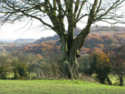
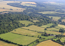
This is defined as gently rolling chalk landscape, eroded by dry valleys with a series of hills, such as Selborne Hill along the eastern edge, forming the summit of the steep scarp to the east. Drift deposits of clay-with-flints cap the highest ridges, including Selborne Common that tops Selborne Hill and the surrounding farmland to the south, west and north. Small areas of chalk grassland surround Selborne Hill.
Key Characteristics have already been defined within the EHDC and SDNP Landscape Character Assessments for the whole area, and in summary are:
- A gently rolling chalk landscape eroded by dry valleys, with a series of hills e.g. Selborne Hill and Noar Hill along the eastern edge, forming the summit of the steep scarp to the east.
- Drift Deposits of clay-with-flints caps the highest ridges and hills (unlike the area to the west where the clay cover is more continuous).
- The areas with heavy clay soils support woodland, including ancient woodland: there are numerous game coverts.
- The majority of the landscape was enclosed during the 18th and 19th centuries, giving rise to the planned landscape of fields, both arable and pasture.
- An area of small scale medieval assarts on the edge of Chawton represents late medieval enclosure of open fields. (As is common across East Hampshire, Selborne has numerous examples of assarts. Classic examples are Hill Field along the bottom of the Hanger and Lawn Acre along the southern margin of Selborne Common).
- Selborne Common, located on an area of clay-with-flints, is a nationally important ecological site (SSSI) supporting mixed woodland and relict areas of open chalk and acid grassland. It is also a registered common, which provides opportunities for countryside access, and is internationally known through the writings of Gilbert White.
- Small areas of chalk grassland survive on the steepest hills and ridges, e.g. Noar Hill SSSI (and The Norrice, a large field between the SSSIs of Noar Hill and Selborne Common).
- The settlement pattern is characterised by scattered farmsteads and hamlets, including the village of Newton Valence.
3.2.1 LOCAL DETAILS OF SELBORNE DOWNLAND MOSAIC Landscape type 3c.
There are three zones of Downland Mosaic, and they divide conveniently as North, Central and South for the purpose of characterisation.
NORTH DOWNLAND MOSAIC (Character Area – 3c)
The Hanger and distant hills from Bush Down. 2012.11.11 4743
An area of farmland with small woodland pockets, stretching from the top western end of Selborne Common North westerly across Bush Down, to Fielders Farm. The western and northern boundaries follow that of the parish, but the eastern boundary with the Upper Greensand Terrace is in need of some realignment. Our findings agree with the National Geological Survey that shows the boundary in the north to be closer to Frenchmare Copse than at Fielders Farm, as interpreted by EHDC.
Ancient Crossing Point (730341) At the extreme northwest corner of Selborne Hill the parish boundary runs from the western edge of the Common, at High Wood, along the western edge of a field formerly known as Laine Veare, but now enlarged to include its northern neighbour, Aylesworth. The boundary crosses Northfield Lane, the lane that leads from Selborne to Newton Valence then cuts north across Northfield Hill and Bush Down. Northfield Lane has a sharp right angled bend that takes the road around the northeast and northwest sides of Aylesworth field. This bend is an ancient junction of pathways, documented back to 1240, as a crossing point of paths between Newton Valence, Norton, and Farringdon. From this important confluence Northfield Lane drops steeply down the southern edge of Bush Down easterly to Coneycroft on its way to Selborne village. For the most part it is a sunken lane, very deep in places and very steep sided, to the point where small trees fall frequently, often onto the road.
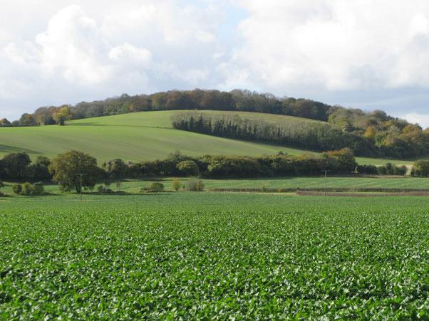
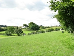
Bush Down (726344) On the north side of Northfield Lane is Bush Down which is bisected by the western parish boundary at its highest point, (180m). Bush Down is a large, open, Middle Chalk field sloping down to the east towards the settlement area.
Bush Down, looking west from just south of Norton. 295
The surface is clay-with-flints and at the top of the hill the flint is very dense. Views from the top are spectacular and very varied. To the south is the high density woodland of the Selborne Hanger in the foreground but with a longer view to the South Downs as a backdrop. To the north is relatively flat farmland: Chawton, Alton, Bentley and Holybourne Down beyond are clearly visible. The view to the east is across the Blackmoor apple orchards to Blackmoor, on to Hindhead, and to the Low Weald beyond. To the west, the view is obscured by the area of woodland called Northfield Hill. The top of Bush Down has a clay cap, (with Flints) and acid soil which today is well maintained and used mostly for arable farming, but not exclusively so.
There is much evidence of ancient farm use. At the top of the hill is an ancient field system; very old beech trees indicate old strip ends in the middle of today’s field. Lower down the slope are probably late Saxon strip lynchets at an elevation of 130m.
These were strips cultivated on Common land, and with a joint harvest. Today the old Common field has been enclosed by hedges that date back 200-300 years and are untrimmed. Two other indicators of long-time use are a possible soil pit, and an iron-age division running along the southern boundary of the field.
CENTRAL DOWNLAND MOSAIC (Character Area – 3c)
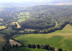 Selborne Hill. The central zone of Downland Mosaic, covers the whole top of Selborne Hill, including, Coneycroft Hill, High Wood, Selborne Common, and Sheep Down. The western boundary is the parish boundary with Newton Valence and physically consists of a sizeable ditch and bank, a thirteenth century earthwork laid out to mark the administrative division between the settlements and to prevent grazing livestock straying from one side to the other The north and south faces of the Hanger are the other boundaries. The north face of the hanger is too steep to graze, but the southern face also has a bank and ditch with a late hedge, approximately 100 years old.
The topography of Selborne Hill can be described in two sections, with north and south zones separated by an imaginary East- West line. In the northwest area is a series of three small and one large scallop contoured valleys. These make extremely interesting walking country, with continual changes of elevation, and numerous pathways give total access to the area. The southern section is much less undulating, containing the bulk of the Common land. The highest point of Selborne Hill is immediately west of the top of the Zig Zag path and this 210m elevation is mostly maintained for the 1km to the western boundary along the Pipeline Path. The elevation drops away to around 170m at the southern boundary. Selborne Hill is steeped in history and as a consequence all areas are named. Names, however tend to be rather fluid and there are different interpretations of where some names apply.
Coneycroft Hill (733337) is the north western spur extension of the Hanger, and it maintains the full height of the Hanger. Most of the hill is detailed in the Scarp section, but the hill itself (which has a rounded end facing NW), is topped by a small, level ancient enclosure and is adjacent to The Wadden. (Note that OS133 marks the location of Coneycroft Hill on the south side of Coneycroft Bottom: most village opinion locates it on the north side. (See NT Newsletter, issue 2 Winter 2010).
The Wadden (735335) behind the northern ridge of the hanger, was an open field in continuous use until 1900, as Common land. Today it is surrounded by dense mature trees, and is approached via Wood Lane and a more recently marked footpath, Wadden Lane, that closely follows the original agricultural track.
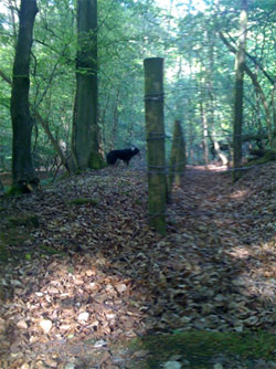
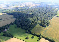
High Wood (730335) is a dense area of old woodland with scalloped valleys, populated with tall Beech and Oak trees on the slopes and old pollards on the flat section and, in parts, much scrubland. The roller coaster landscape makes disorientation easy but the footpath network is very good. High Wood is marked on OS133 as Coneycroft Hill.
Selborne Common (734332) covers Selborne Hill: it was grazed by Commoners’ cattle until 1950, but no longer resembles a Common in the conventional sense. Long term efforts are under way to clear scrub, as well as some coppicing and pollarding, to restore the ancient grazing lands, under the management of the National Trust. (There are many old once pollarded trees across the Common).
Low intensity grazing. 820
Low intensity grazing has now begun again within the Common enclosure, with an occasional small herd of local cattle. Entry to the common from the Zig Zag path is via a clearing at the top of the Scrubbs. This provides one of the most spectacular views in the south of England, to the east, over Oakhanger to Box Hill on the horizon 44km away. This open area is one of several being carefully managed (with Hemp-Agrimoney, Blackthorn etc.to encourage rare butterfly species.
There are four houses built on what was once Common land, two of them close to the top of the Zig Zag. They are partly screened behind trees, but with their screening they severely restrict the sweep of the viewing angle at the top of the Zig Zag. (In White’s time there was a ninety degree clear sweep. On the north side, the tree density is higher but in winter the village can be seen 90m below and can be viewed by taking the Wadden Lane path on the right.
The clearing rises to a gated entrance to the common which opens to the enclosure of Sheep Down with the The Pipeline and Lower Race pathways directly ahead. The Pipeline Path, formerly the Middle Race cuts west across the common until it reaches the Newton Valence boundary. The path begins as a wide, grassy track with open woodland on either side. Most of the trees are beech and several trees, marked by a green tag, are veterans of special interest and high ecological value. As the path becomes more open it is flanked by blackthorn and bramble bushes; this area is very popular with fruit pickers in the autumn. Towards the mid-point on the left is an open area still known as the boys’ cricket pitch and soon the path widens and enters a large grassy area which used to be the men’s cricket pitch.
At the far side is Wood Pond, a dew pond now in need of clearing out. Around this area are various benches, now used by picnickers. The Clay-with-Flints here holds the surface water well and the path here can become very muddy. The trees change to hazel and other indigenous varieties, some of which are pollarded. After a junction of five tracks, marked by a signpost, it reaches the gateway that is the end of the Sheep Down and the beginning of Newton Valence parish.
The Pipeline is a popular walk and approximately 1km in length. Today it mostly resembles a wide ride in woodland, up to the central clearing, but the restoration process is gradually opening up tracts of grazing land along the way. Blackthorn is in evidence all the way along. Many of the mature beech trees alongside were pollarded. Most of the Common has a capping of Clay with Flints.
Sheep Down (734328) is the Common area to the south of the Pipeline, and this is traversed by The Lower Race through pollarded woodland and on the southern side, mostly hazel scrub, stretching down to the bank and ditch boundary with the Kings Field and Westcroft. The boundary also has a hedge about 100 years old and a modern wire fence. Footpath 17 runs inside the boundary, alongside the bank and ditch for approximately 300m of its length. There has been extensive scrub clearance on the south side of the Common and more views south are being made available each year.
SOUTH DOWNLAND MOSAIC Character Area – 3c
This is the Downland Character Area immediately south of Selborne Hill, a mixture of grassland and arable farmland. The Character Area between the Hanger and Noar Hill west of the B3006 is marked as Greensand Terrace on the county LCAs. The British Geological Survey and our own observations have shown the boundary in this area south of the village to be around 200m east and closer to the B3006 than the EHDC marked boundary. It is however very fractured, with outcrops of Greensand appearing in the Chalk areas.
The Kings Field runs most of the southern edge of the common. 049
The Kings Field (742332 to 736327) is the first field on the south of the hanger, running west from the southern end of the Scrubbs, below the three incursive fields on the Common: it is almost 1km in length but is sub-divided. Kings Field is separated from the Common by a classic ancient bank and ditch with a mixed-species hedge dating back around 100 years. Access is from the Hangers Way or from FP17, both off Plum Fell Lane. The Hangers Way follows the southern edge of the field, and wear and tear has exposed the Middle Chalk at one of the crossing styles. For the first 200m the path runs along a ridge overlooking an ancient track, 3 metres below. This track is the remainder of the original route along Plum Fell Lane to both the Kings Field and Galley Hill. FP17 emerges on to the Kings Field from one of the incursive fields, approximately 200m along, at the top edge.
The views from this point are spectacular. To the south, the immediate view is the slope extension below the Kings Field, called Galley Hill. Across the valley, at a distance of approximately1 km is the Chalk scarp Noar Hill with the High Wood Hanger. To the east (115deg) is Blackdown in West Sussex, clearly visible at a distance of just under 20km.
To the south west is open, undulating farmland towards the Meon Valley.
Views to the north are all close range and are dominated by the woodland on the southern Chalk Scarp of the Selborne Hanger.
The eastern end of the Kings Field is steeply sloping and very narrow, in fact the field is wedge shaped at this end. This widens out along its length to around 300m at the western end, but the gradient reduces. The narrow east end is privately owned and has stabling and paddocks for the first 50m. The following grassland is divided into equine exercise areas with temporary fencing until a mature hawthorn hedge indicates change of ownership. The easternmost fields were obviously strip farmed along the contours, as is evidenced by the land profile. After the hedge there are two more sequential sections of this field, both hedged with mature species, mainly hawthorn. The first has an obvious lynchet, complete with a hawthorn tree indicating that the strip was ploughed parallel to the Common boundary. This section stretches the full distance down from the common boundary to Galley Hill Lane, the road that runs up the valley from the B3006. It also accommodates the only building on the Kings Field, Homestead Farm, built approximately 100 years ago, and surrounded by paddocks, outbuildings and the remains of a very old orchard about 200m x 50m.
The Hangers Way exits Kings Field close to the farm, crossing Galley Hill road before reaching the slopes of nearby Noar Hill. The final westernmost section is shallower and has a different strip pattern, having one wide horizontal strip, and the remainder ploughed at right angles down to the road. The final hedge separating this field from the larger Westcroft is older and contains many mature trees. The three westernmost sections are regularly grazed by cattle and sheep as well as by horses.
Galley Hill seen from the Kings Field 767
Galley Hill (743333 to 740327) The Hangers’ Way footpath at the lower edge of the Kings Field looks down, on the south side, onto an old agricultural track for approximately 200m. This track is a tree lined tunnel that forms the southern boundary of the Kings Field and the northern boundary of the first two Galley Hill fields that slope down to Galley Hill Lane. Along its northern side is a long narrow, 2-3m wide, formerly-ploughed strip, now wooded but very obviously visible. Being on a south facing slope and protected below steep banking, it was possibly used for cultivating vines.
On the southern side is a classic bank and ditch with a hedge, and trees. This is a private lane now, but in past times it was the agricultural access to the Kings Field and to the Kite Hill gallows for local dispensation of justice.
At the end of the track, the boundary between the Kings Field and Galley Hill becomes a conventional bank and ditch, with a substantial hedge. Galley Hill itself is a wedge shaped strip of land that is the southern continuation of the downland slope from Selborne Common and the Kings Field to Galley Hill Lane, the valley road to East Tisted. At the north eastern (B3006) end, the first two fields slope gently down to the road.
Kite Hill. 765
The third field rising up Galley Hill is more interesting: originally named Ell Piece, it has steep, multi-directional slopes, and is an interesting view in itself, from both FP17 and the Hangers’ Way. Interest centres on the complex arrangement of the various slopes. Galley Hill Cottage, the only house on this field, is built on the site of an old lime kiln, and it is possible that the complex profile is a direct result of lime excavation.
At the top end is a small, steep sided promontory, Kite Hill, thought to be the site of the local gallows. It is important from a conservation viewpoint because this hill has never been ploughed and as a consequence is an invaluable source of wild plant seed, being used to help recreate natural meadows in the area.
An ancient stipulation against ploughing was presumably because the slopes were too steep. It is currently rotationally grazed by sheep. The fourth field is almost a plateau and leads to Homestead Farm, built on the southern edge of the Kings Field. This is maintained for horses and for occasional cattle grazing. Views from Galley Hill Lane are limited as it is a sunken lane with steep sides and mature hedging on both sides, and a dense tree tunnel along the steepest section of the road. On the south side, Galley Hill Lane lies behind an old hedge with many different species of hedge and tree, Wayfarers, Hazel, Viburnum, Field Maple, Spindle, Rose and Cornus are all present.
The lower (eastern) end of Galley Hill Lane is blighted by B3006 traffic noise, but this diminishes as it climbs Galley Hill where the lane becomes very sunken (5m), before reducing, though it does not disappear on climbing to the top of Galley Hill. This is a particularly interesting area for field birds. Sounds that have been noted include song birds, (thrush, blackbird, robin), buzzards, green woodpecker, bullfinch, and possibly blackcap. Green is a dominant summer colour, but views of cut cornfields make the view towards Noar Hill glow. The grassland area is in general is very well maintained, and is being conserved very professionally in the interesting zone around Galley Hill Cottage/Kite Hill by all the landowners in partnership with the National Trust. All fields are well maintained, although with the caveat that continuous horse-only grazing can and does destroy the field character. The Galley Hill fields are positioned strategically between Selborne Common and Noar Hill and will feature heavily in the efforts to provide nature corridors, pathways for the interconnection of breeding grounds for at-risk species, which may include both butterflies, (Brown Hairstreak, Duke of Burgundy), and birds, (eg. Yellowhammers).
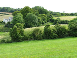
Westcroft is the only cultivated field on the southern edge of the Common. 114
Westcroft Field (736327 to 730324) Westcroft is the field at the western end of the Kings Field. It is gently sloping and south facing, running off the edge of the southern boundary of Selborne Common. A medium sized field, approx. 600m x 400m of open arable farm land, it is regularly cultivated, typically with a crop of oats. At the extreme northwest corner the field boundary cuts up into the Common for the last 200m of field length, to a depth of around 100m.
This area is not cultivated, presumably because the slope is steeper, being a continuation of the Common profile. There is no public access and it can be viewed only from the boundaries that are Selborne Common (N FP17), Green Lane (W), the bridleway at the western end, or from Galley Hill lane, (S). Both FP17 and Green Lane are tranquil places, with a pervasive smell of composting woodland. Surface features are difficult to identify as they are mostly invisible under crops but the aerial photos do show possible evidence of field strip cultivation in the north-south orientation. Although apparently featureless, it does provide a welcome relief from the uniform green of the grazing fields to the immediate east. This is a continuation of the small Downland Mosaic, along the southern edge of Selborne Common. Buzzards overhead are common in this area. Westcroft is a fine working field in good condition and well maintained. The scrub area in the corner is presumably a wild set-aside but, being so densely covered in Ragwort, it looks of marginal value for conservation purposes.
Green Lane borders the entire western end of Westcroft field. It is today a wooded tunnel connecting Selborne Common with Galley Hill Lane and, although the banks are encroaching, the width in places is up to 4m. The OS133 map shows it as an almost straight line: in practice this is not the case, and at the approximate mid-point, the lane looks to curve away west towards the Longhope Manor House in Newton Valence, and may possibly have been an original access to the house. There is a definite direction change to the NE, now leading to the Common. Green Lane has suffered in the recent past from fly tipping, and has on occasions been completely blocked. Being quite remote, there remains a continuous danger of this being repeated.
With strange wildlife. 747
Green Lane and is very dark. 748
South of Galley Hill Lane two large fields, Clays and The Norrice, run sequentially up the hill to Lower Noar Hill Farm and the parish boundary. Clays, the lower field, is bordered on the eastern edge by the B3006 road, and this boundary roughly follows the transition from Middle Chalk to Greensand. In its most northerly corner is a short, but steep sided, valley in a strip of woodland that leads up to the source of the Wellhead Stream. On the Galley Hill Lane side of the stream are two houses, one old and built of malmstone and brick, the other modern. These have wooded land reaching down to the stream bank.
The Wellhead Stream (744327 to 744330)
The Wellhead valley is overgrown. In the foreground is the original header tank for the Victorian water distribution system that fed the village.751
Beside the B3006 entrance to the village from the south The Wellhead pours unceasingly through the Lions Mouth Monument to Gilbert White. This is a well-known landmark. There is a walk from the Lions Mouth through scrub woodland and alongside the Wellhead Stream, emerging into the lower Clays Field. This replaces the old wooded path that has become impassable. Eventually, it is possible to descend steeply through the thicket to reach the source of the stream. The Wellhead runs north into Selborne from the Lions Mouth alongside the B3006 and eventually joins the Seale stream, from the northern end of the village, to form the Oakhanger Stream. The Lions Mouth is a Victorian monument, given by a benefactor, a Mr. Mills of Portsmouth who was born in Selborne. This provides a fountain and trough. It is mounted on a substantial retaining wall which also houses a parallel water outlet and an enclosure with a pumping system, previously used to distribute water around the village. The pump is backed up by a brick built pressure tank, set approximately 40m upstream and on a raised level, about 10m above the road. Immediately behind the retaining wall the pathway follows the course of the stream, which has cut a steep sided valley through the chalk marl.

The Lion’s Mouth. 759
There are no extensive views owing to the scrub woodland along the whole length of the stream. The old, original, path alongside the stream sits mainly on an overgrown plateau on the southern side. The northern side of the stream is a very steep sided cut into the chalk that sits below the field gardens of the two houses.
Approximately 150m along, a dam has been created to provide a reservoir once used by the then Brunstable Farm for field irrigation. Above the dam the source of the stream is accessible. This shows evidence of manual intervention in the past to build up support to keep the exit clear.
Greensand malmstone was used, and many fragments lie in the immediate area. The Wellhead washes down fine sand covering the bed and has filled up the various water overspill capture areas, dug into the hill behind the Lions Mouth retaining wall. The stream woodland is enclosed but has a heavy noise from the B3006. This gives way progressively to the water movement. The atmosphere here is very damp, with a pervasive smell of rotting woodland. Out in the fields it becomes very open and contrastingly fresh.
The industrial archaeological remains do convey something of the time when this was the water supply for the village. It was pumped all around and even supported Laundry Cottage, sited just across from the Lions Mouth. The land containing the Wellhead from the source to the Lions Mouth is in the ownership of the Parish Council. It is poorly maintained with no woodland management and, as a result, the original path has largely vanished. The replacement, parallel, path is accessible but kept open only by usage rather than maintenance and this has to exit the council land well before reaching the source. The stream itself needs some maintenance; there is a threat from build-up of sand behind the retaining wall and this may cause flooding in very wet conditions. The reservoir is choked with weeds but this does not seem to restrict flow.
Clays (747326 to 743325) is a relatively flat field, with extensive flints, and is used as arable farmland. The view east is restricted by the trees lining the B3006, and to the west by a mature windbreak of lime trees that screens Norrice field in summer time. The field, once part of the vanished Brunstable Farm, was called the Clays, (1842), and extends south from the stream alongside the B3006. Its southern edge is the Selborne Parish boundary hedge, unfortunately not original in this section as it was removed in error and replaced in 1990. At the western end, is the substantial windbreak of lime trees, separating the Clays from The Norrice. The Parish Boundary continues along the southern edge of The Norrice, including a length of the original ancient hedgerow. Away from the B3006 these are quiet fields. The walk through Clays, past The Norrice, is a well-trodden path connecting the southern end of the village to Noar Hill.

The Norrice – pure downland. 784
The Norrice (743325 to 740325) field is at the western end of The Clays, further up Galley Hill. The Norrice is pure down land, a large up-sloping chalk marl open field with a domed top that has been arable but is now in transition to become natural grazed grassland, with the intention to restore the natural biodiversity through an active programme of wild seed distribution. The Norrice has no public footpaths but is visible from both Galley Hill Lane and from the path that runs along the western end of the Clays then diagonally across the field that is immediately to the south of The Norrice, leading to Noar Hill. Views from the lime tree screen to the west are only of the field itself. Views south are towards Noar Hill with the ancient southern hedgerow marking out the parish boundary. There are signs of strip lynchets running north-south across the upper part of the hill.
This whole area is an important potential wildlife corridor between Selborne Common and Noar Hill. Efforts are underway to create breeding bridges or at least stepping stones for various species that have been lost to one or other of these two important SSSIs. This can be done by re-introducing plant species that will restore the natural biodiversity that existed when now lost colonies thrived. An early target is to try to re-establish breeding of the Brown Hairstreak butterfly on Selborne Common, by migration from the small colony on Noar Hill. Both fields are well managed with responsible ownership and the future looks to be very interesting from the biodiversity viewpoint.
There have been changes: sadly the parish boundary ancient hedge along both fields was partially removed and, although replaced, many species were lost. The remaining ancient part alongside The Norrice logged nine species. The new part has only four. Some old trees were left in the area around a pond that has dried up in recent years. The collaboration of local landowners with the National Trust to return fields to grazed grassland and restore pockets of bio-diverse hedging, with sensitive management, (no flails and three yearly cutting for example), promises the real possibility of improvement.
3.3 SELBORNE GREENSAND TERRACE – Character Area 6a
The Selborne Geensand Terrace character area is defined by its geology forming a distinctive broad Upper Greensand “terrace” stretching north to south through the district, with a locally prominent greensand escarpment on the eastern ridge. To the west the boundary is marked by the steeply rising chalk escarpment of the Selborne Hangers to East Meon Scarp, with the eastern edge defined by the lower lying claylands of the Rother Valley. The Greensand terrace and its associated escarpment are most clearly defined in the north – to the north of Selborne the Greensand scarp becomes more dominant in the landscape than the chalk scarp. Towards the south (Petersfield), the topography becomes more undulating.
Key Characteristics have already been defined within the EHDC and SDNP Landscape Character Assessments for the whole area, and in summary are:
- A terrace formed from Upper Greensand with locally prominent escarpment clothed in woodland defining its eastern edge.
- Cut by a series of small streams, (e.g. Oakhanger Stream) that rise from springs at the foot of the chalk escarpment, and have eroded narrow, deep valleys as they cross the Greensand Terrace.
- The sandstone geology gives rise to sunken lanes where steep banks reveal tree roots and exposures of the bedrock geology, and which have a high biodiversity value. (e.g.Huckers Lane)
- Fertile and well drained grey loamy soils which have supported a long history of settlement and cultivation, including orchards.
- Ancient hanger woodlands (e.g. Milking Hanger), a habitat of international importance, and comprising a range of nationally uncommon woodland types, such as those dominated by yew, beech, lime, ash and wych elm, cling to the steepest slopes forming a woodland silhouette.
- Meadow grasslands (Lythe Meadow SSSI) which are important sites for invertebrates, particularly where found in association with other habitats such as scrub and woodland.
- An area of orchards around Selborne is a distinctive land cover feature.
- The area is well served by public rights of way including the Hangers Way which runs the length of the character area and is accessible from Petersfield, Selborne and East Worldham.
- Diversity of field patterns and enclosures including to the south, small irregular fields carved from woodland indicative of medieval assarts.
- Low density settlement characterised by small nucleated medieval settlements.
- A strong sense of rural tranquillity resulting from the absence of overt human impact and a low density of settlement.
- Building materials are typically local “Malmstone”, with red brick detailing and clay tile or Thatch roofs.Where woodland permits, there are dramatic views of the chalk escarpment.
3.3.1 LOCAL DETAILS OF SELBORNE GREENSAND TERRACE – Landscape type 6a.
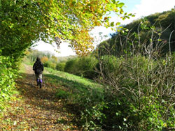
The view east, along The Long Lythe section of the Hangers Way. 237
6a Selborne Greensand Terrace. A terrace formed from Upper Greensand with a locally prominent escarpment clothed in woodland defining its eastern edge. To the east of the B3006 road, all Selborne landscape is on the Greensand terrace and the sandstone geology gives rise to sunken lanes, (Huckers Lane, Honey Lane, Sotherington Lane, Bradshott Lane), and is cut by both the Wellhead and Seale streams that rise from the foot of the chalk escarpment, later to combine forming the Oakhanger Stream that eventually joins the River Wey. To the south of the village is the major watershed, where the most southerly Adderhood stream heads to the south via the River Rother.
Although it is the Chalk scarp Hanger that provides the drama in the Selborne landscape, it is the Geensand Terrace that provides the most defining character. The terrace supports a mixed land cover of woodland, and farmland, of small pasture fields and paddocks and is the largest of the three character areas, covering the settlement area and extending to the parish border in the north, east and south.
The woodland with oak, beech, ash and hazel includes distinctive hangers, (e.g. Milking Hanger, Wick Hill Hanger), with remnants of ancient woodland that cling to the steepest of slopes. Small streams cut through these steep woodlands, adding to the ecological diversity of the landscape and create an undulating landform. Drift deposits of clay, silt sand and gravel occur in association with the streams.
This is small scale landscape of intimacy and enclosure, provided by the woodland cover and sunken lanes, contrasting with more open arable areas. The character area is unified by its terrace landform and woodland hangers. Views are restricted or channelled, often confined along sunken lanes but, where woodland permits, there are dramatic views of the chalk escarpment, for example the view from the eastern end of the Long Lythe to the Hanger.
The Greensand character area occupies the entire eastern half of the total area considered, encompassing farmland in the north, almost the entire settlement area, the greensand hangers (Milking, Wick Hill, Sparrow), to the east and northeast, the farm land including the extensive orchards in the south east, down to the southern hangers, Adderhood and Oakshott. At the southern end is the major watershed that sees the Selborne streams, (Wellhead, Seale and Oakhanger) head for the Thames via the River Wey and the Adderhood from Noar Hill to the Channel via the River Rother. The Wellhead and Adderhood sources are just 1km distant.