Selborne and its Hangers
Whatever the approach, by road, lane, track or pathway, Selborne village appears as something of a surprise, well hidden in the surrounding landscape, as if in a hollow, but in fact perched high on the junction of the Upper Greensand Terrace and the Lower Chalk and overlooked by its Hanger.
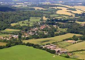
Aerial view from the southeast of the village. The Hanger is on the left. 030.
This is interesting countryside, due to the contrasts caused by being located where the extreme western edge of the Weald meets the Chalk promontories at the northern-most edge of the down-land stretching west, back to the Salisbury Plain.
The main approaches are from the north and south on the B3006 road that bisects the village, faithfully following the Lower Chalk –Upper Greensand junction that leaves houses on opposite sides of the road with very different soils in their gardens, (heavy clay to the west, tilth to the east). The B3006 links the village with the neighbouring towns of Alton and Petersfield, and with neighbouring villages to the east and west via three sunken country lanes. Access on foot by the popular Hanger’s Way, is one of nine local paths entering the village, and has approximately 4km of its length in the parish.
From any direction, it is Selborne Hanger that commands first attention; the village being hidden from view, nestling some 85 metres below the ridge of the Chalk Scarp.
The village and its Hanger are synonymous. When inside the village, the Hanger always feels present and is clearly seen from almost every point: sometimes close, sometimes more distant, but always there thanks to the clear space around the base; a continuous strip of village fields giving views that distance the settled area from the Hanger. The village is visible from above from well-established viewing points on the Hanger, made famous and more accessible by the 18th C naturalist, Gilbert White its best known and most celebrated former resident.
The village and its Hanger are synonymous”. 174
Selborne Hanger is The Hanger, but there are others on the Upper Greensand Terrace to the east: they are less dramatic, but add much to the diversity and beauty of the local landscape.
The Lythes in the northeast of the village are the start of a continuous chain of greensand hangers that run through Candovers and on to East Worldham: to the southeast, the Adderhood and Oakshott Hangers twist and turn to link with the Squiresfield and Le Court Hangers of Empshott.
Selborne and its Landscape
Selborne has sharply contrasting landscape and is defined by it: there are three immediate landscape character areas here. The village sits at the foot of the east facing and steeply wooded Hanger that wraps around Selborne Hill. This Hanger is the north eastern extremity of the Selborne to East Meon Scarp, topped and surrounded by large scale downland mosaic.
The settlement area is linear in character and stretches along the junction of the Lower Chalk -Upper Greensand Terrace of East Hampshire.
Selborne’s landscape has long been recognised as an outstandingly beautiful area, and given extensive protection since originally being included within the East Hampshire Area of Outstanding Natural Beauty, (AONB) a national recognition, and having the majority of the village designated a Conservation Area. The AONB and the protection it provided has been superseded and strengthened by full inclusion in the recently created South Downs National Park, (SDNP). In addition to the Park Authority protection, the Selborne section of the Wealden Edge Hangers, more commonly known as the East Hampshire Hangers, falls within a Special Area of Conservation (a Natura 2000 site) under the EU’s Habitat Regulations (2000). This enhances the protection that Selborne Hill and the Lythes receive as Sites of Special Scientific Interest, (SSSI) under UK law. Additional site specific areas are Sites of Importance for Nature Conservation, (SINC). Having been recognised as an area rich in bio-diversity, most of the landscape around Selborne has recently been included within a Biodiversity Opportunity Area, (BOA), a designation that aims to reduce the fragmentation and isolation of protected sites and the ecological enhancement of areas around and between them. This protection has been superseded and strengthened by full inclusion in the recently created SDNP. We are fortunate to have two of our prime landscape areas, The Hanger/Selborne Common and Church Meadows/The Lythes, owned and well maintained by The National Trust which in effect provides another tier of statutory protection through its Acts of Parliament and ownership in perpetuity.
Selborne’s name simply originates from the stream (bourne) along which sallows (willows) grow, and clearly the abundance of springs and streams (caused by the junction of the clay with easily permeable chalk) attracted early habitation.
Note: The name Hanger is derived from the Anglo Saxon, Hangr, and was one of many words used for woodland. Others are still in use today, Wudu, wood, Graf, grove, Scaga, shaw. Others, Bearu and Fyrhp have been forgotten. We use Hanger for a steep wooded slope, but it is not clear to what types of woodland the Anglo Saxon names applied, but there are hints that it may have been used originally to describe a slightly concaved wooded slope. An analysis of the topography associated with the name hanger indicates that a wooded slope is or has been a feature of the landscape, although it doesn’t always have to be a steep slope. The name occurs in clusters and is by no means evenly distributed across England. It also appears that the usage of hanger in place names is relatively recent although there are a few medieval records in which it appears. It probably became fashionable to use hanger as a name for a wooded slope during the last few centuries. The use of hanger has probably shifted from a term for a sloping wood to a proper name, Hanger, hinted at in Gilbert Whites’ Natural History of Selborne. Within the village ‘the Hanger’ is used as a proper name. Outside the village ‘Selborne Hanger’ is often used to precisely locate which hanger is being referred to although earlier, local people may have referred to hanger in the sense that it was the sloping wood on the side of the Hill rather than as a specific geographical area.
Selborne’s Historic Landscape
The major lineaments of the Selborne landscape are determined by geology, and the human imprint is relatively minor, even considering the extensive but small scale chalk and malmstone quarrying over the past few hundred years. The human contribution is to the vegetation taken as a whole, with the presence of woodlands, meadows, heaths and arable fields. There is evidence of settlement within the parish from the Early Mesolithic with radiocarbon dates ranging between c. 7300 – 6800BC at Oakhanger. Bronze Age, Roman, and Anglo Saxon sites surround the area evidencing long episodes of, or perhaps continuous, habitation. There are 30 registered Archaeological Sites in and immediately around the village, which also has 49 listed Historic Buildings. We are fortunate that much of our landscape has remained unchanged since the earliest habitation, due mainly to the Hangers being too steep for cultivation.
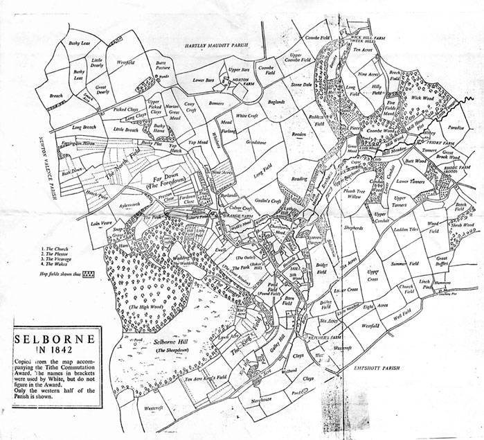
Many old field patterns remain, as do the original names and our surveys use these names wherever not superseded by modern ones. The same applies to the various woodland areas. The 1842 tithe map is still a valuable source.
Our recent village history is relatively well documented, with publications ranging from “The Natural History of Selborne” by Gilbert White, published in 1789 as the world’s first true natural history book, right up to the recently published history of Selborne, “Knights Priests and Peasants” by local historian and geologist Dr Edward Yates published 220 years later.
Selborne Today
The village of Selborne thrives with an active community of just over 300 households. Unusually for such a small community, it supports a village shop and Post Office, a first school of outstanding quality, two tourist shops, two pub/restaurants, a pottery, an art gallery, and Gilbert White’s House, The Wakes, a world famous museum that also houses the Oates Museum and an award winning tea parlour.
The museum and the stunning village landscape with some of the country’s best walking, attracts up to 39,000 visitors per year. There is a Church, Village Hall, a recreation ground, tennis court, play area for children, garden allotments, numerous walks and bridleways. Surrounding the village are farms, arable and livestock, (cattle, sheep and pigs), together with the more specialised producers of salads, apples, cider and lavender, with its associated products. On the debit side, the village has the increasingly busy B3006 road running right through the centre, with up to 10,000 vehicles a day using the road in a commuter traffic tidal flow that the village desperately wants reduced, but so far has not found the resources or political solutions to make the necessary changes. Out of the village some bye-ways have become severely damaged by excessive and destructive off-road vehicle use, including a woodland section of the Hangers Way path.
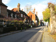
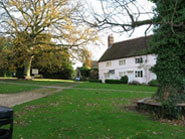
The Street and Wakes Museum. 162
The Plestor. 166
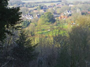
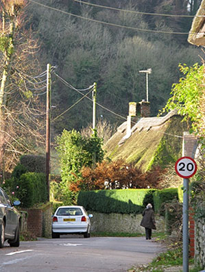
The view from the Zig Zag. 22/2
Selborne Local Landscape Character Assessment (LLCA)
The scope of this LLCA covers only Selborne and its parish as far as the boundaries with the two villages that share the parish, Blackmoor and Oakhanger.
The descriptive sections of the LLCA are as follows:
Section 2. An introduction to the LLCA, setting out the objectives, and the methodology for its production.
Section 3. Detailed descriptions of our three Landscape Character Areas.
Section 4. A concluding summary of what is important to the village.
Section 5. Aspects of village biodiversity: this is not complete and awaits the results of various studies in progress.
Section 6. Village maps.
Section 7. Appendices.