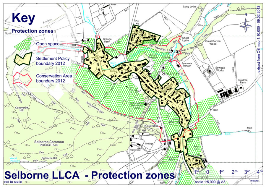
4. What Is Important That Must Be Preserved
Open Spaces
A number of villages have historic buildings and pretty thatched cottages and are dominated by wooded hillsides. Selborne is different and special because there are open spaces (including pastureland) within the village that afford views to the surrounding countryside which helps to maintain the sense of rural tranquillity. Examples within the village include The Plestor, Barnfield (Under the Hill), Church Meadow and School Field. These must not be built on, nor should they be allowed to develop in any way that compromises the views. For example Barnfield is in danger of losing its open grassland character due to a hedge planted around ten years ago cordoning off a quarter of the field. This includes ash trees, already several metres high: the views are already obstructed and we recommend removal since it serves no practical purpose since there is a partitioning wire fence to contain the grazing animals.
Equally important is the pastureland that encloses the village settlement area and examples include the pasture at Culver Croft (Burlands Field), Kimbers, the Ewell Field and all the other fields behind Gracious Street. All the ancient open spaces must be preserved for future generations. (See Appendix II for a complete list of Village Open Spaces to be Preserved).
Historic Village
Much has been written about the history, geography, climate and natural history of Selborne by its famous son, Gilbert White. What is remarkable and worth preserving is that the village and its setting in the Hampshire countryside is much as it was at the time of his death at the end of the 18th century.
“At the foot of the hill, one stage or step from the uplands, lies the village, which consists of one single straggling street, three quarters of a mile in length, in a sheltered vale, and running parallel with the hanger”.
White – the Natural History and Antiquities of Selborne.
Size and Linear Structure
The village nestles into the surrounding countryside, in part because of its scale. It has, of course, grown since White’s day but the settlement has retained its linear character. Although it has expanded to the north in the form of Goslings Croft, (originally a council estate for agricultural workers) and to the south with an affordable housing estate at Ketchers Field, the overall shape of the village has been maintained. It is important that within its current settlement boundaries, its traditional linear character should be maintained by limiting back-land development, respecting the existing street pattern and resisting any further estate-like housing development that would suburbanise the village.
Sunken Lanes
The village street and the lanes that branch off it provide great visual interest – narrow, bending, rarely flat, they give ever-changing views. Mature hedgerows and trees with few narrow or mostly non- existent pavements give a rural feel throughout the village. Sunken lanes are a particular feature of this part of East Hampshire. They are valuable as wildlife habitats and many date back to pre-Roman times. The erosion of the soft chalk or greensand by horses, cattle and carts that resulted in lanes that are up to 20 feet below the level of surrounding land, has been arrested by resurfacing. Many of the lanes have become minor roads. However, erosion of the banks continues as tractors and other heavy vehicles churn up the soft soil in the passing places when allowing other traffic to pass.
It is important that Planners consider the impact on these historic sunken lanes when considering granting planning permission for activities in the countryside, even if they are small scale. These increasingly include change-of-use industrialisation of farm buildings, new installations such as anaerobic digesters or operational bases for agricultural contractors. The adverse impact of increases in the number of heavy vehicle movements on these lanes, must weigh heavily in their decisions. There is a particular concern with Honey Lane: the density of very heavy agricultural machinery movements has increased as a result of a recent establishment of a contractors’ base that services surrounding farms. In a short space of time new damage has been recorded and some restoration work may be required.
Unspoilt Views
Although most of the lanes and roads enter the village uphill, an enduring part of Selborne’s charm is that it remains hidden from view. Approached from the north, the Hanger dominates the view across the fields of Norton Farm until the B3006 bends sharply into the village past Goslings Croft. Unfortunately, the view of the Hanger from the south is spoiled by one or two obtrusive houses built on its upper slopes. No new development must be permitted on the skyline or ridges surrounding the village, nor should the field cordon around the hanger be built on.
The views from the village and from the many footpaths that criss-cross the area are an important feature and are greatly valued by residents and visitors alike. However, a number of significant views are marred by electricity and telephone lines that are strung along the roadways. There is a considerable cost attached to sinking these lines underground but it would be a price worth paying in certain locations where unobstructed views are worth preserving. There is intrusive cabling in all the streets and lanes of the village, including Gracious Street, The High Street, Plum Fell Lane, and Huckers Lane.
Sustainability
The village infrastructure is delicately balanced. The community survives with precious assets such as the school, the shop and post office, the pub/restaurants, the Wakes and Oates museums, and most of all its rural tranquillity and landscape that is an integral part of the village centre. These assets must all be preserved.
It really is a delicate balance: to maintain the rural quality there is a minimum of street furniture even though the main B3006 road through the centre carries excessively heavy traffic. There are no street lights, traffic lights, roundabouts, etc.: we don’t have them and village opinion is strongly opposed to their introduction. The very recent installation of the 20mph signs has provoked negative comment on their ubiquity. The fact is that the village open spaces allow visual access to the countryside from most parts of the road.
To maintain the sustainability of the village we have to limit development to very small units that will not disturb the balance. It has been offered by potential developers that more houses will help sustain the village but a recent Planning Inspectors’ report correctly revealed the fallacy of this. (See Appendix l). The school for example has no current need of extra pupils; it is already turning away potential pupils from neighbouring villages, but demographics will need constant monitoring here: the village shop would only gain a very small percentage of new incomer trade that would inevitably go mostly to the increasing number of local supermarkets, (two new ones are in Alton since this report was started) and there would inevitably be an increase in village traffic, already indicated in the Village Plan as the major negative aspect of life here.
The landscape within and around the village is the prime asset that must be protected to maintain the desirability and delicate sustainability of the place.
Village Character
The village has a strong character, formed by history, landscape, the settlement and its population. There are continual efforts to maintain and strengthen this character, through the various village institutions, and in particular to make improvements in areas where the village character is being eroded. The following are highlighted.
- The traffic level has already been cited as the villages’ biggest problem and daily jams mask the beauty of the place, as well as causing physical damage. Examples of damage may be seen to the historic Plestor House where the stonework has totally eroded due to traffic splashing and vibration. Buildings right on the High Street are regularly damaged by over-large trucks or overloaded agricultural trailers. White Cottage has had its roof hit three times in the recent past. The Old Forge was hit with damage to the roof and corner of the building, and as a consequence a rash of bright orange bollards has been installed. These are totally out of character and are an unwelcome intrusion. The wooden posts used at the crossing pinch-points are much less intrusive, but are continuously being demolished. The solution must be to enforce the laws that restrict both the speed and size of vehicles in the village, and not clutter up the centre with unsightly protection devices.
- The central car parking area is neither big enough nor of sufficient quality to support the influx of daily and tourist traffic. (Ref: Village Plan)
There are efforts being made to resolve these issues, but a second tier of issues identified as eroding the character have emerged from this LLCA, and these are summarised below. Some are referred to above as conservation or landscape issues, but here is how they affect village character:
- Some place names have been somewhat arbitrarily changed over many years. Original names still in current use do add significantly to the character and sense of place; for example; Gracious Street, Honey Lane, Huckers Lane. Names that have been changed if not entirely lost have been raised as an issue for discussion, and there is much sentiment in the village to have some of these restored, particularly a reversion of the main street back to The Street, instead of the urban sounding High Street. The other most notable is the erroneously named Plum Fell Lane, originally Punfle Lane, (which in turn derived from the Pound Field that it crossed). (Parish Council action for discussion with EHDC?).
- Intrusive overhead cabling affects the sense of place and alters the character. (Parish Council action for discussion with Scottish and Southern Electricity?)
- Narrow sunken lanes take their character from their age, depth and narrow width and hedgerows. They do need protecting from modern agricultural machinery that all seem to be oversize for these lanes. (PC to monitor and measure damage?)
- To the south of the village some fields have been given over to high volume apple production. This is a large successful agribusiness, welcome in the community but it does change the character of the landscape adjacent to Ketchers with regimented rows behind high deer fencing. This is reminiscent of vineyards and is perhaps a vision of the future of farming in this area. It is hoped that such industrial scale farming will not impact the local biodiversity by the application of its technology through spraying etc. (Check for any impact study by Blackmoor Estates?)
- The Hangers with their magnificent beeches dominate the scenery here. We are all faced with the possible effects of global warming, and there are fears that the beeches may eventually disappear. Since most are in the care of the National Trust we need their input on the likely consequences, and details of any planned response, such as planting replacement species. (Check with NT)